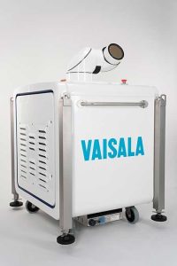
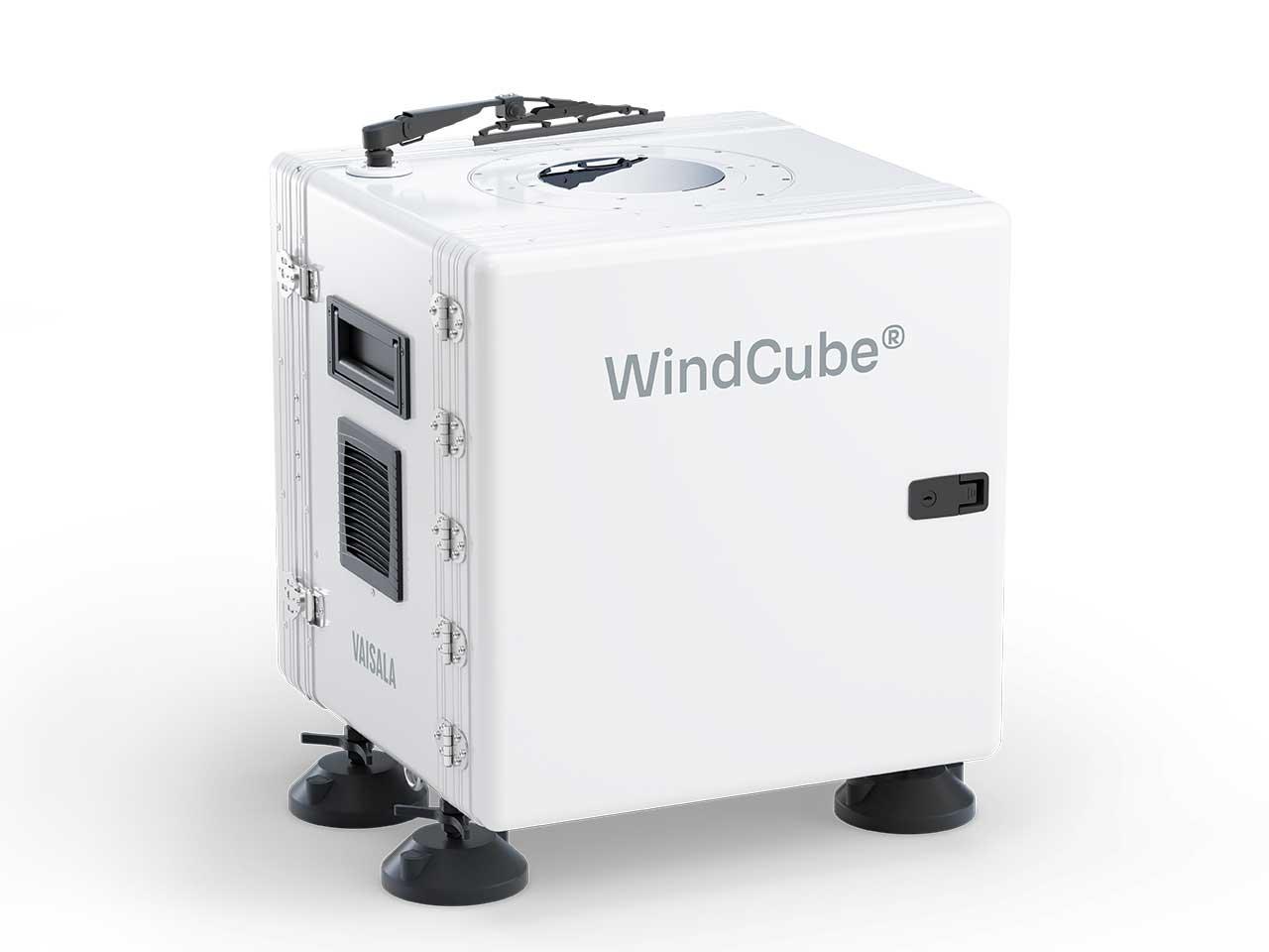
Manufacturer: Vaisala
Model: WindCube® 2.1 XP
WindCube® is a ground-based vertical profiler lidar that measures accurate wind data up to over 400 meters. It is equivalent to a very tall met mast, collecting wind speed, direction, vertical wind speed, and turbulence intensity data at 20 different heights with limited installation constraints and high operational safety.
Based on pulsed Doppler heterodyne laser principle, the WindCube sends a light pulse at a high frequency into the atmosphere and observes the signal backscattered by aerosols naturally present in the air. The time between the pulse and the detection of the backscattered signal is processed by the system thanks to the Doppler effect, and provides an accurate measure of the wind speed and direction.
Pulsed laser technology
Pulsed Lidars send laser pulses at a very high frequency. To avoid confusing time delays and distance, the Doppler shift is analyzed before the next laser pulse is emitted. Therefore, the probe distance, or height, only depends on the time it takes for a pulse to be received after it has been emitted.
Multiple heights are measured simultaneously, and spatial resolution is constant throughout the entire wind profile. Also, measurement accuracy is
not affected by clouds, fog, high density of dust, or obstacles.
Thanks to a vertical beam, the lidar allows a direct measurement of the vertical wind speed, and improves the turbulence intensity (TI) assessment.
Remote monitoring
The web‑based Vaisala Compass platform enables remote monitoring and control of the WindCube vertical profiler. Wind speed data are displayed live, and the platform also provides the possibility to configure measurement heights and communication with the Lidar.
Ease of installation and operations
The Lidar is easy to handle and install. A couple of hours is enough to fully set up the lidar and start measuring. It is compatible with autonomous power solutions (power pack, solar panels), and its robustness supports operations continuity.
1. Operating environment
| Specifications | Value |
|---|---|
| Operating temperature | −30 °C to +55 °C / −22 °F to 131 °F (chamber conditions) Radiation +1000 W/m² at +50 °C |
| Maximum operating altitude | 4000 m (2000 m with provided ACDC converter) |
| Operating humidity | 0–100 %RH, non‑condensing |
| Environmental protection | Designed for installation in many kinds of weather and environmental conditions IP66 (WindCube complete system) and IP67 (optical head compartment) |
| Pollution degree | PD3 |
| Rain protection | Wiper and hydrophobic window |
| Marine atmosphere (Salt Atmosphere Compliance) | IEC 60068-2-11 (240 hours) |
| Shocks and vibration | ISTA/FEDEX 6B |
2. Mechanical specifications
| Specifications | Value |
|---|---|
| Cube dimensions (L × W × H) | 554 × 566 × 554 mm (21.81 × 22.28 × 21.81 in) |
| With feet and wiper |
608 × 566 × 661 mm (23.94 × 22.28 × 26.02 in) |
| Weight | 59 kg (system only) 28 kg (shipping case only) 91 kg (total with accessories) |
3. Electrical specifications
| Specifications | Value |
|---|---|
| Input Power Supply DC Insulation class: Overvoltage category |
18-32 V DC Class III (PELV used) OVC II |
| Input Power Supply AC with the transformer provided by VAISALA Insulation class: |
100-240 V AC 50/60 Hz Class I (PE connected) |
| Power consumption | 35 W between −5 °C and +30°C (23 °F and 86 °F) 105 W below −5 °C (23 °F) 50 W over +30 °C (86 °F) in chamber conditions |
4. Compliance
| Specifications | Value |
|---|---|
| Compliance marks | CE, FCC, IC, UKCA |
| Laser safety compliance | 1M Class – EN 60825-1:2014 + A11:2021 |
5. Measurement specifications
| Specifications | Value |
|---|---|
| Measurement range | 40 to > 400 m Constant measuring probe (spatial resolution) |
| Data sampling rate | 1 Hz (average frequency on horizontal wind speed) |
| Measuring distances | 20 user-defined distances simultaneously |
| Radial Wind Speed range | −28 … +28 m/s |
| Reconstructed Wind Speed range | 0 – 60 m/s |
| Reconstructed Wind Direction range | 0 – 360° |
| Speed accuracy | 0.1 m/s |
| Speed uncertainty | 40 – 85m: 1.3% to 1.6% 90 – 130m: 0.6% to 1.2% 135 – 200m: 0.35% to 0.5% |
| Direction accuracy | 2° |
| Beam geometry | 4 inclined beams at 28° and 1 vertical beam |
6. Data output
| Specifications | Value |
|---|---|
| Output data | 1 s / 1‑, 2‑, 5‑, 10‑minute averaged (user-defined) horizontal and vertical wind speed Standard deviation Direction CNR (carrier-to-noise ratio) Data availability |
| Complex terrain measurements | FCR unlimited license |
| Data storage | Up to 5 years storage of all output data on 2 embedded industrial disks (main and back-up) Vaisala Compass secured cloud-based server |
| Data file format | .rtd and .sta (TSV files), ISO-8859-1 encoding |
| Communication | Wifi, LAN, 4G router (router availability upon region/country), Modbus RTU, Modbus TCP |
| Time synchronization | GPS, NTP |