
Introduction to HimawariCast Groundstation System
The HimawariCast System is a high-performance automatic satellite ground receiving station designed to receive meteorological cloud imagery from Japan Meteorological Agency’s Himawari-8 satellite via the HimawariCast Service. Operating in the C-band, the system collects, decodes, and visualizes satellite data to support meteorological monitoring and forecasting.
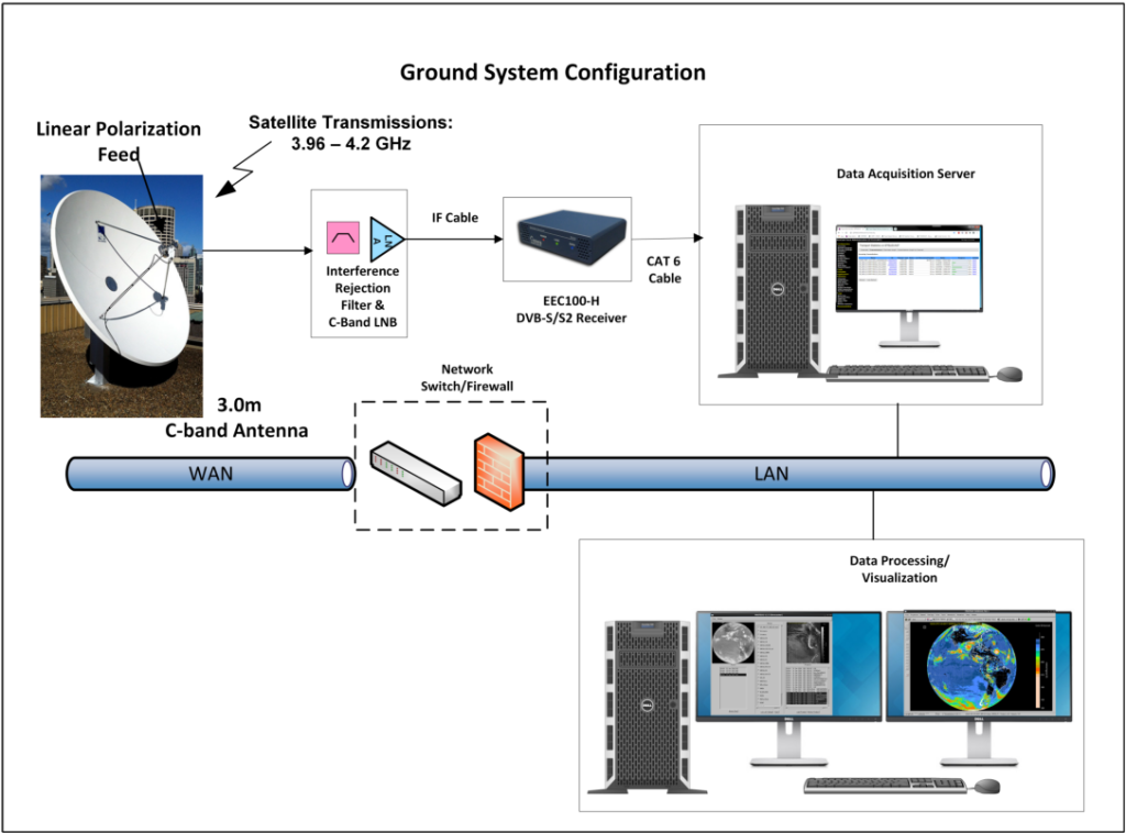
Type: 2.4m diameter parabolic dish
Mount: Heavy-duty pedestal mount for tropical outdoor use (rooftop or ground-based)
Features: High signal stability and effective rejection of high-frequency interference
Feed Horn: Converts C-band microwave signals into electrical signals
Frequency range: 3.4 – 4.2 GHz
Operating temperature: -40°C to 60°C
Band Pass Filter (BPF): Suppresses out-of-band interference
Passband: 3.4 – 4.2 GHz
Out-of-band attenuation: 25–30 dB
Operating temperature: -40°C to 60°C
LNB (Low Noise Block Downconverter)
Gain: 62 dB (typical)
Noise temperature: 25K
Output frequency range: 950 – 2150 MHz
Local oscillator frequency: 5150 MHz
Frequency input: 950 – 2150 MHz
Data rate: Up to 80 Mbps
Remote control via TCP/IP
Front-panel LED status indicators
Controls DVB-S2 receiver
Handles data reception, decoding, and local storage
Manages data ingestion using specialized software
Converts raw satellite data into Level 2 products
Processes Level 1 & 2 satellite imagery
Auto-generates map overlays, color tables, and annotations
Supports output formats: GEOTIFF, JPEG, PNG, etc.
Displays and analyzes satellite imagery
Supports formats: HDF, GEOTIFF, PNG, GIF, KMZ, etc.
Overlays NWP (Numerical Weather Prediction) data
3D cloud rendering, animations, distance/area measurements, and data plotting
Displays satellite imagery and weather forecast products
Supports ground observation, radar, IR brightness temperature, etc.
Includes panoramic views and animated loops
Cloud Top Pressure, Height, and Temperature
Cloud Type and Cloud Fraction
Land Surface and Sea Surface Temperature
Hotspots (Wildfires), Fog, Dust, Volcanic Ash
Convective Activity, Rainfall Estimation
RGB Composites: Natural Color, Air Mass, Dust, Snow/Fog, Volcanic Ash
Contact us for more information!


