1. General Introduction
An FLS is a system for measuring wind and metocean conditions, installed on an offshore floating platform, and uses LiDAR (Light Detection and Ranging) technology to remotely measure wind without the need for a fixed meteorological mast.
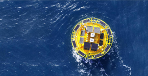
BA-FLS-NX5 is the commercial model of FLS which is designed based on proven technologies and design principles that emphasize resilience, accuracy, safety, and reliability. It follows general technical conditions for navigation buoys and it has track records of more than 70 projects in China, Japan, Thailand, the UK and the Philippines, has experienced typhoons, storms, and cold weather with snow and ice.
2. System Description
An FLS may operate tens or even hundreds of miles offshore and must withstand strong winds, waves, and unexpected events such as vessel collisions. Beyond data accuracy, we believe reliability is the most critical factor in FLS design.
2.1. Specifications of BA-FLS-NX5
| Modules | Details |
|---|---|
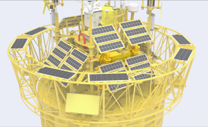
| Floating Platform |
Diameter: Φ5m; -Height: 9m; -Weight: 15t; -Net Buoyancy: 10t Structure: multiple cabinets; -Materials: PE, Carbon Steel, Stainless Steel Lifetime of design: more than 10 years |
| Mooring System |
Water depth: >6m Chains, standard length pro chains: 27.5m; thickness: 42mm Anchor: cement anchor and high holding power anchor |
| Control System | Industrial PLC |
| LiDARs |
ZX 300M / WindCube Offshore V2.1 / Molas B300M Dual LiDAR: select any TWO of the three LiDARs |
| Weather Station | SW700-C × 3 |
| Power Supply |
Battery Capacity: total 60kWh in multiple groups; Wind Turbines: 2×350W; Solar Panels: 2464W, multiple groups; Fuel cell(optional): 2×125W with 8 tanks of fuel (224L) |
| Navigation System |
IALA-compliant navigation light×2; |
| Positioning System |
Directions: 0-360°; -Direction accuracy: 0.09° (2m baseline); Positioning accuracy: 0.5m (horizontal, SBAS mode) |
| Motion Sensors | GNSS-INS × 3 |
| Communication Systems |
SAT Modules: Iridium SBD×1,Inmarsat SBD×2, Broadband SAT data modules×1; Mobile Networks: 2G/3G/4G×1; 2.4G/5G Wi-Fi×2; Local Ethernet connection |
| Data Acquisition | Industrial PC×3 ; -Interfaces: Serial×6, Ethernet×2 |
| Met-Ocean Sensors (Optional) |
Doppler current sensor(ADCP): xylem AANDERAA DCPS5400×2; Water depth sensor: VA500 ×1 and ISA 500 ×1; Water salinity and temperature sensor(surface): Valeport mini CT×2 ; |
2.2. System Architecture
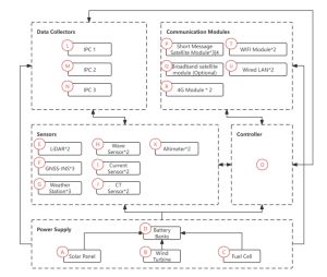
| Ký hiệu | Tên thiết bị | Chức năng / Mô tả |
|---|---|---|
| A | Solar Panel | Main power supply |
| B | Wind Turbine | Main power supply |
| C | Fuel Cell | Backup power supply |
| D | Battery | Energy storage |
| E | LiDAR | Wind measurement |
| F | GNSS-INS | Direction and motion data for calibration |
| G | Weather Station | Weather parameter measurement |
| H | Wave Sensor | Wave parameter measurement |
| I | Current Sensor | Current parameter measurement |
| J | CT Sensor | Water temperature and conductivity measurement |
| K | Altimeter | Water depth measurement |
| L | IPC1 | Data collection & storage & transmission |
| M | IPC2 | Data collection & storage & transmission |
| N | IPC3 | Data collection & storage & transmission |
| O | Controller | Device power on/off control |
| P | Short Message Satellite Module | Remote data transmission & control |
| Q | Broadband Satellite Module | Remote data transmission & control |
| R | 4G Module | Remote data transmission & control |
| T | WiFi | On site data transmission & control |
| U | LAN Wired | On site data transmission & control |


